
Aeropath – Fly with Confidence
Project Info
-
CATEGORY:
- Aviation , Travel , Utilities
-
FEATURES:
- GPS
- Radio Finder
- Bluetooth Integration
- One Touch Frequency Update to Radio
- In App Purchase
- AVAILABLE ON:
Case Study
On a mile final at 70 knots you’ll reach the runway in 72 seconds. So if you’re approaching your airport and listening to ATIS, and looking up the Tower and Ground frequencies, and checking your V-speeds, and running through the checklist, and holding heading and glideslope, and getting instructions from the controller, just remember, 72 seconds! Doesn’t it make sense to simplify the whole procedure?
Here’s what you don’t need. The stress of doubling and tripling your cockpit workload. A lap full of directories, diagrams and notes. Guessing what ATC is going to ask next. Not knowing where to taxi when you land. Not having the answers. That’s why there’s Aeropath. To keep your flying simple and keep you in control.
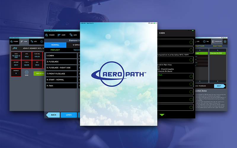
Look up any US airport. Can’t remember the name? Type in the city. Now you’re looking at the airport, its radio frequencies and an airport diagram. The radio tiles are in order of use: ATIS, Approach, Tower, Ground, etc. No hunting, no dog-eared directory pages, bookmarks or Post-it notes.
We’re pilots just like you. Aeropath is what we’ve always wanted – less stress from pre-flight to tie-down and everything in between. Ease of use makes mastery of flying attainable. Ask any flight instructor. If they have fewer things to do the confident student learns to get things right the first time. Confident pilots are then ready for the next level. That’s our mission.
Key Features Overview:
● Airport Finder™ locates any US airport by city, name or identifier.
● COM Panel shows all VFR communications settings for airports, shown in typical order of use.
● Log of viewed airports with Favorites for quick lookup.
● Airport Diagrams: all current FAA surface charts.
● Taxi-Trace™ draws a course directly over the Airport and Airspace diagrams.
● Class B Airspace shows airspace boundaries/altitudes for major US airports.
● Automatic Updates for all data and charts.
● Interactive checklists for most popular aircraft, download from anywhere.
● Checklist logs show step-by-step procedures, completion status for all sessions.
● V-Speeds for all conditions of flight.